Dynamic Earth and Maps
These activities introduce the idea of dynamic Earth—a planet with continuously moving surface. Kids get to build a mental model of Earth’s interior and reconceptualize continents as fragments of the planet’s outer shell floating on top of the molten interior (a shift from the static and solid representation of Earth as promoted by the classical maps and atlases of the world). Children will create a flip book illustrating continental drift and link the continental positions to geological epochs. The activities introduce the concepts of plate tectonics, volcanism, “Ring of Fire,” planetary evolution, and the effects of large scale geologic transformations have on human populations.
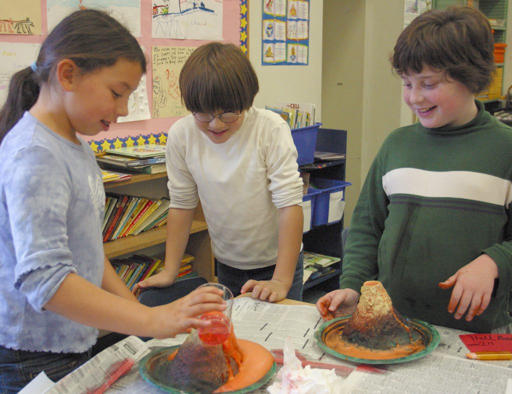
Kids start by considering the history of scientific explorations relating to the above theories. They proceed with building and “exploding” a volcano model. And they will make contour maps of their volcano islands and write fictional stories about the life on that island.
Main Ideas
Research
- Research is the basic tool of well-educated people. While engaging with Supermarket Science Activities, kids learn how to conduct and think about research in general and how to look up basic information about the rock formation, continental movements, the deep geologic history of our planet, and how humans deal with natural disasters in a library or the Internet.
Precision
- Each label, name, or word has a specific meaning that all scientists in the same field understand to mean exactly the same thing.
- Descriptions of objects and events need to be precise enough to limit misunderstanding or misinterpretation by the readers as much as possible.
- Fuzzy thinking” is not allowed!
Logical Thinking
- There two pathways in science: deduction and induction. Deduction is a process that puts together bits of data and evidence to build a theory—it’s bottom up reasoning. Induction is the process that starts with an idea and then looks for data and evidence to support it—it’s top down reasoning.
- Logical reasoning is a formal way of thinking (usually deductive) where each successive thought is built upon the previous one; as long as each link is a chain of logical reasoning is true, the end conclusion is true.
Geological Processes
- Geology is the study of the Earth and its composition. The word “geology” is a compound word, composed of “geo” meaning “Earth” and “logy” meaning “study.” Geology literary means “a study of the Earth.”
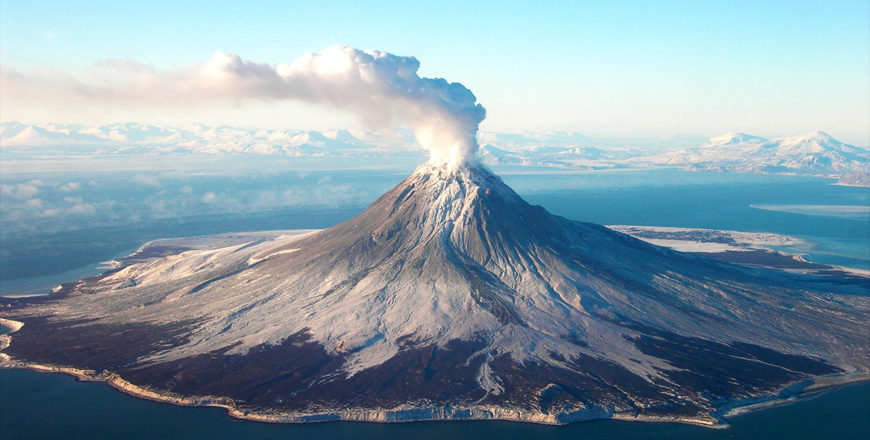
- “Ring of Fire” is an imaginary line on the earth atlas connecting the volcanoes on the edges of the continental plates. The ring includes the volcanoes on the west side of South and North Americas, the volcanoes of Alaska, and the volcanoes of Japan and the Pacific Rim. The “center” of this ring is the Hawaiian Archipelago, which itself has a group of active volcanoes.
- Continental drift is a theory about the movement of continents.
- Plate Tectonics is a theory which describes the movements of the Earth’s upper crust. According to this theory, the Earth’s surface is broken into large plates. The position and size of these plates change over very long periods of time. Where these plates rub against each other, there is intense geological activity: earthquakes, volcanoes, and mountain building.
- “Hot Spot” is a theory that tries to account for volcanoes that exist in the middle of tectonic plates rather than on the edges. A hot spot is a fixed spot in the Earth’s mantle that, for currently unexplained reasons, is hotter than the surrounding areas. As the continental or oceanic plates move over such spots, a volcano develops. Hawaiian Archipelago is an example of volcanic islands formed over a hot spot.
1
A Crusty Story
If we dig a really, really, deep hole into the Earth what would we find? What’s inside? That’s an interesting question to which we still don’t have a very good answer. Even now, we know surprisingly little about our planet’s interior. For example, we don’t really know how hot it is at the center. Scientists estimate an internal temperature anywhere between 7,000°F and 13,000°F. That’s a 6,000°F swing! If a student was that far off on a test…well, you get the idea. In comparison, the surface temperature of the sun is 13,000°F. How come our feet are not hot from just standing on the ground?
It’s hard to figure out how hidden things, like the interior of the planet, work. And scientists, being people too, sometimes have prejudices and fixed ideas which blind them to the truth. Most people think that scientific discovery is an orderly and rational process. So the reality of how scientific advances are made is sometimes surprising.
2
Plate Tectonics
A 1:13 snippet from the BBC documentary film "Earth The Power Of The Planet "
3
Continental Drift
A brief overview by Mike Sammartano of the theory of continental drift and the evidence supporting it. This video explores how the apparent fit of the continents, fossil and rock correlation, and paleoclimate data support Alfred Wegener's ground-breaking theory.
4
Building a Volcano Model
Now that we've learned something about volcanoes, we need to make one! All it takes is some paper, glue, paint, and some ingenuity.
5
How Earth Will Look In 250 million Years
According to plate tectonics theory, Earth's outer shell is divided into multiple plates that slowly glide over the mantle. This slowly changes Earth's surface over time by merging, or separating, continents.
6
Topographic Maps
Maps are flat, but real world isn’t. So how can we show on the map how far a person would have to walk get over a mountain? How hard would that person have to climb to get over the top? To solve this problem, cartographers invented topographic maps. Topographic maps show the terrain (the surface features) and land forms in a measurable way. In addition to accurately representing the horizontal distances, topographic maps devised a notation to accurately represent vertical distances on a flat map.
7
Eruption
Now that you have a volcano model and you have exploded it a few times, it is time to document what happened: make a map of the volcano island and the path of the lava flow down its sides and then write a newspaper article about the day of the eruption.
https://sites.google.com/site/geographymapskills/map-symbols
Expect to spend at least a week working through these materials. Some of this time is waiting for the volcano model to dry out enough to be ready for paint. Then the paint needs to dry. But there's a lot to do while you are waiting on your models.
No announcements at this moment.
Be the first to add a review.
Please, login to leave a review